Hurricane Ian: Where is the storm that's wreaking havoc across Florida heading next?
After taking down power in Cuba, Hurricane Ian is wreaking havoc across Florida...


By now, you likely have heard of Hurricane Ian, the pretty dangerous typhoon that's currently making landfall as one of the most intense hurricanes to hit southwest Florida on record.
As far as weather-related catastrophes go, Ian and the recent triple-dip La Niña are pretty big deals.
According to The Weather Channel, Ian currently boasts maximum sustained winds of 155 miles per hour and is classified as a strong Category 4 hurricane.
"Ian's storm surge has arrived along parts of the southwest Florida coast, including in Naples, Florida, where over 6 feet of storm surge inundation has been measured, more than any other storm at that gauge location in at least 50 years," reports the outlet.
Folks have been taking to Twitter to illustrate the extent of the downpour and its consequences via photos and commentary.
Currently in Fort Myers, Florida. Video by Loni Architects #flwx #Ian #hurricane pic.twitter.com/8nfncFlG9GSeptember 28, 2022
Here is a time-lapse of the #StormSurge coming in on Sanibel Island, #Florida caught on a live traffic cam. This was only 30mins condensed down, it deteriorated quickly. 😬 #HurricaneIan #Hurricane #Ian pic.twitter.com/JKuNROvMm4September 28, 2022
First-person view of storm surge from Hurricane Ian in Fort Myers Beach, FloridaThe camera is 6 feet off the ground‼️pic.twitter.com/bQSF3MkaPTSeptember 28, 2022
When did Hurricane Ian first make landfall?
The storm has been so intense that it actually knocked the power out in all of Cuba, which is not too far from Florida, on Tuesday night. The New York Times reports that officials are currently working on restoring it.
Unfortunately, at least two people were killed there.
Sign up for the woman&home newsletter
Sign up to our free daily email for the latest royal and entertainment news, interesting opinion, expert advice on styling and beauty trends, and no-nonsense guides to the health and wellness questions you want answered.
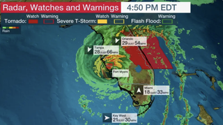
According to reports, Hurricane Ian first hit the coast of southwest Florida today, at which point the National Weather Service issued its "extreme wind warning." The Weather Channel reports that the outlet only does so "in situations of the most intense winds in stronger hurricanes." A tornado watch is in effect across central and southern Florida now through at least 5pm EST.

Although plenty of residents in parts of coastal Florida are currently under evacuation orders and advisories, Governor Ron DeSantis warned that folks in Collier, Lee, Sarasota and Charlotte should stay put as it is too late to leave.
Where is Hurricane Ian going to hit next?
Current hurricane warnings stretch all across the Florida Peninsula to the state's Space Coast, including cities like Daytona Beach, Fort Myers, Orlando and Tampa-St. Petersburg. Florida's west coast is also being monitored, as is the northeastern part of the state all the way to Charleston County in South Carolina ("where hurricane conditions are possible," reports The Weather Channel).
People in Northwestern Bahamas are also being asked to be vigilant as Ian might make an appearance there.
Perhaps most worrisome, though, are the reports regarding the possibility of the storm becoming a Category 5 one.
"Ian will remain at least Category 4, but could make an extremely rare Category 5 landfall this afternoon," explains the Weather Channel. "Regardless, Ian will be a life-threatening, catastrophic landfall, one of southwest Florida's strongest hurricanes on record."
What impact will Hurricane Ian have?
"Ian will remain at least Category 4, but could make an extremely rare Category 5 landfall this afternoon," explains the Weather Channel. "Regardless, Ian will be a life-threatening, catastrophic landfall, one of southwest Florida's strongest hurricanes on record."
Among the many impacts already noted by experts is a storm surge along parts of the southwest Florida coast. "The peak surge, possibly up to 18 feet, will occur near and south of where the center makes landfall in southwest Florida on Wednesday," reports The Weather Channel. "That could be between Englewood and Bonita Beach, including Charlotte Harbor." The surge is also expected to hit the Atlantic side of northeast Florida, coastal Georgia, and parts of South Carolina starting tonight and into tomorrow.
Meteorologists are also warning everyone about wind surges and heavy rainfall. The latter threat will likely affect the Florida Peninsula and portions of the Southeast well into the weekend.
Wind damage, on the other hand, will likely impact the same areas as the flood. As a result, folks should be aware of possible structural damage along the storm's path, plus power outages and downed trees.
Clearly, the impact of Ian will last way beyond the end of the storm.
Anna Rahmanan is a New York-based writer and editor who covers culture, entertainment, food, fashion and travel news. Anna’s words have appeared on Time Out New York, the Huffington Post, Fortune, Forbes, Us Weekly, Bon Appetit and Brooklyn Magazine, among other outlets.
-
 Keira Knightley styles the best chocolate brown blazer with a blush pink skirt, coffee tone jumper and white slingback heels
An oversized blazer is the answer to our cold-weather styling dilemmas
By Molly Smith Published
-
 Shetland season 9 ending explained: Who murdered Annie and Bergen?
We delve in the Shetland season 9 final episode to unpick everything happened, and find out who was responsible for the death of Annie and Bergen.
By Lucy Wigley Published